a giant island of plastic in the Pacific ocean, "Twice the size of Texas."

Pacific Ocean garbage patch worries researchers
By MICHELLE RINDELS (AP) – 3 days ago
LOS ANGELES — A tawny stuffed puppy bobs in cold sea water, his four stiff legs tangled in the green net of some nameless fisherman.
It's one of the bigger pieces of trash in a sprawling mass of garbage-littered water, known as the Great Pacific Garbage Patch, where most of the plastic looks like snowy confetti against the deep blue of the north Pacific Ocean.
Most of the trash has broken into bite-sized plastic bits, and scientists want to know whether it's sickening or killing the small fish, plankton and birds that ingest it.
During their August fact-finding expedition, a group of University of California scientists found much more debris than they expected. The team announced their observations at a San Diego press conference Thursday.

"It's pretty shocking — it's unusual to find exactly what you're looking for," said Miriam Goldstein, who led fellow researchers from the Scripps Institution of Oceanography at UC San Diego on the three-week voyage.
While scientists have documented trash's harmful effects for coastal marine life, there's little research on garbage patches, which were first explored extensively by self-trained ocean researcher Charles Moore just a decade ago. There's also scant research on the marine life at the bottom of the food chain that inhabit the patch.
But even the weather-beaten, sunbleached plastic flakes that are smaller than a thumbnail can be alarming.
"They're the right size to be interacting with the food chain out there," Goldstein said.
The team also netted occasional water bottles with barnacles clinging to the side. Some of the trash had labels written in Chinese and English, hints of the long journeys garbage takes to arrive mid-ocean.
Plastic sea trash doesn't biodegrade and often floats at the surface. Bottlecaps, bags and wrappers that end up in the ocean from the wind or through overflowing sewage systems can then drift thousands of miles.

The sheer quantity of plastic that accumulates in the North Pacific Gyre, a vortex formed by ocean and wind currents and located 1,000 miles off the California coast, has the scientists worried about how it might harm the sea creatures there.
A study released earlier this month estimated that thousands of tons of plastic debris wind up in the oceans every year, and some of that has ended up in the swirling currents of the Great Pacific Garbage Patch.
Katsuhiko Saido, a chemist at Nihon University, Chiba, Japan, told the annual meeting of the American Chemical Society last week that plastic actually does decompose, releasing potentially toxic chemicals that can disrupt the functioning of hormones in animals and marine life.
The Scripps team hopes the samples they gathered during the trip nail down answers to questions of the trash's environmental impact. Does eating plastic poison plankton? Is the ecosystem in trouble when new sea creatures hitchhike on the side of a water bottle?
Plastics have entangled birds and turned up in the bellies of fish, and one paper cited by the National Oceanic and Atmospheric Administration estimates 100,000 marine mammals die trash-related deaths each year.
The scientists hope their data gives clues as to the density and extent of marine debris, especially since the Great Pacific Garbage Patch may have company in the Southern Hemisphere, where scientists say the gyre is four times bigger.
"We're afraid at what we're going to find in the South Gyre, but we've got to go there," said Tony
Haymet, director of the Scripps Institution.

Only humans are to blame for ocean debris, Goldstein said. In a blog entry posted a day before the science ship arrived in Newport, Ore., she wrote the research showed her the consequences of humanity's footprint on nature.
"Seeing that influence just floating out here in the middle of nowhere makes our power painfully obvious, and the consequences of the industrial age plain," she wrote. "It's not a pretty sight."
http://images.tribe.net/tribe/upload/photo/cd1/7ad/cd17adc9-084b-400f-99a1-7255ef65d698
Located halfway between California and Hawaii lies the Pacific Ocean's Great Garbage Patch. Double the size of Texas, it consists of -- you guessed it -- trash.
A natural phenomenon, The Garbage Patch is part of a system of currents called the North Pacific Subtropical Gyre. Its contents are caught in a swirling vortex, created by slack winds and sluggish currents.
This pollution is killing sea life, choking birds and fish, entangling seals and whales, as well as assaulting the Hawaiian Islands.
The island chain acts like a giant comb, straining floating trash onto its coral reefs, beaches and shorelines, including the Big Island's southern Waiohinu-Ka Lae coast. More than 50 tons of marine debris from domestic and foreign sources wash ashore annually in Hawaii, said Carey Morishige, Pacific Islands outreach coordinator for the National Oceanic and Atmospheric Administration's Marine Debris Program. Morishige spoke Saturday evening about this deadly problem and what is now being done to address it. Seven residents attended the "Got Trash: Protecting Hawaii's Oceans From Marine Debris" lecture at the Outrigger Keauhou Beach Resort. Some suggested the poor attendance was reflective of the public's "out-of-sight, out-of-mind" view of marine debris.
"Marine debris is any man-made object discarded, disposed of, or abandoned that enters the coastal or marine environment," states NOAA's National Ocean Service. "It may enter directly when it is lost or dumped from a ship or indirectly when debris washes out to sea via rivers, streams and storm drains."
Since the onset of synthetic materials, such as plastics, marine debris has become a threat to wildlife, Morishige said. Oftentimes, floating bits of debris are often mistaken for food and ingested, leading to internal injury, dehydration and starvation, death.
Morishige has seen the remains of a foraging Laysan albatross from the Northwestern Hawaiian Islands. Its exposed belly filled with shiny bits and chunks of plastic among the bones and feathers. "It's heartbreaking," she said.
Rubbish also can wrap around fins, flippers and limbs of animals, causing drowning and amputation. In 2002, Morishige said a humpback whale was entangled in 22 different types of net, making it more susceptible to other threats like ship strikes.
"Some debris can kill for decades, especially since trash far outlives us," she said.
For instance, it takes 450 years for plastic bottles to decompose, 600 years for monofilament fishing line to degrade, 10 to 20 years for plastic bags to decay, one to five years for cigarette filters to break down, two months for an apple core to disintegrate and two to four weeks for a paper towel to deteriorate, according to the U.S. National Park Service Mote Marine Lab in Sarasota, Fla.
Marine debris has become a navigational hazard to fishing and recreational boats by entangling propellers and clogging cooling water intake valves. Repairing damaged boats is consuming and expensive. When a cargo ship -- traveling from California to Japan -- got its propeller stuck on an enormous ball of floating net, it took divers and specialist three days to remove it, Morishige said.

After all, giant balls of derelict net are often discovered in the ocean. During a helicopter survey of a whale entanglement, NOAA officials spotted 12 balls, about 30 feet in width, floating off the Kona coast, Morishige said.
On Dec. 22, the President Bush signed into law the Marine Debris Research, Prevention and Reduction Act, which provides $12 million annually in federal funding for the effort through 2010. Of that, NOAA will receive $10 million and $2 million goes to the Coast Guard.
Since 2005, NOAA has funded numerous projects to help prevent, reduce and mitigate marine debris.
The NOAA Pacific Islands Fisheries Science Center Coral Ecosystem Division is surveying and removing marine debris from the main Hawaiian Islands.
Flying up to five hours daily from February through May 2006, the science center obtained global positioning system data, photos and other information to map the distribution and abundance of the debris. It noted 771 marine debris sites, which are comprised of about 250,000 pounds of trash, Morishige said.
Most of the sites were in the windward coastlines, except the Big Island. Researchers believe currents and micro eddies sweep pollution down the West Hawaii coast and wrap it around South Point, Morishige said.
Last year, NOAA and the Hawaii Wildlife Funds held five cleanups in an effort to make the Waiohinu-Ka Lae coastline cleaner and safer. Each cleanup tackled a different section over four months.
The ending result was "phenomenal," Morishige said. Hundreds of volunteers filled about 900 garbage bags, collected 84,922 items and removed about 41 tons of marine debris from this coastline. Of that, almost 36 tons were derelict fishing net, enough to fill three 40-foot Matson Navigation Company containers.
The collected net was placed in a container and shipped by Matson to Covanta Energy's H-Power facility in Honolulu, where they are burned to create electricity. About 100 tons of derelict net creates enough electricity to power 43 homes a year, Morishige said.
Despite the progress made last year, the marine debris has returned to the Waiohinu-Ka Lae coastline and another series of cleanups will be organized, Morishige said.
"NOAA is working toward source identification, but until then, removal is just a Band-Aid, something we can do now to help mitigate the problem," she said.
To increase awareness about marine debris, NOAA is creating a public display at the Mokupapapa Discovery Center in Hilo, which is tentatively set to debut Jan. 27. It will feature actual marine debris items collected from various locations on the Big Island as well as results from the NOAA's aerial survey project.
For more information about marine debris, contact Carey Morishige of the NOAA Marine Debris Program at 397-2651, ext. 256, or e-mail her at Carey.Morishige@noaa.gov. Also, visit www.marinedebris.noaa.gov.
Tue, January 9, 2007 - 9:31 AM
Plastics, including polyethylene and polypropylene, are synthetic polymers that have remarkable strength, flexibility, and durability. They're used extensively in every aspect of modern civilization, from cars to medical devices to naughty toys. It is their durability, however, that causes the problem.
Instead of being biodegradable, plastics are photodegradable. This means that instead of being broken down by biotic processes such as bacteria, they are broken down by exposure to light, particularly from the sun. The other critical difference is that, where biodegradable substances are returned to the life cycle in the form of natural chemicals, photodegradable plastics are just broken down into smaller and smaller pieces, creating a large volume of molecular-sized synthetic polymers.
One of the chemical properties of these polymers is that they absorb and give off different chemicals, some of which are nonylphenols, PCBs, and the infamous DDT. When plastic in the ocean is eaten by living organisms, the toxic chemicals within are released into that organism. In phytoplankton, toxic chemicals are consumed and then passed long the food chain up to higher trophic levels, and the concentration of these chemicals increases exponentially at each level, in a process called biomagnification.
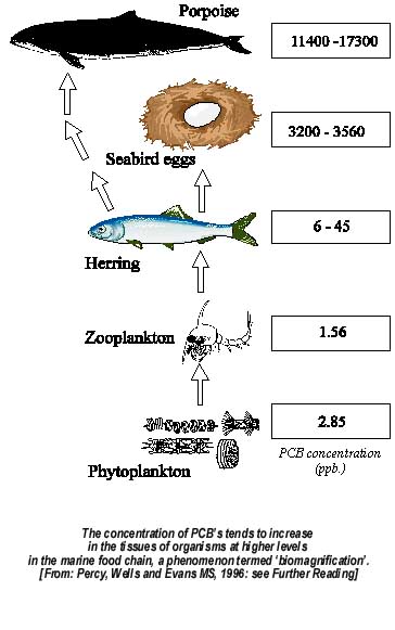
(http://www.bofep.org/Publications/Fundy%20issues/biomagnification.jpg)
Following the diagram above, replace the porpoise with a person, and consider how people are truly integrated in the global ecosystem.
The amplification of these toxins can have profound effects on higher organisms. In the case of DDT, the accumulation in birds makes their shells weaker, and so, when attempting to incubate their prospective young, the parent birds inadvertently crush the eggs, destroying any hope of a subsequent generation.
In the case of birds, such as this late albatross, small plastic objects look like food, but lack the same nutrients:

(http://www.tripdance.org/IMAGES%20Web/Poisoning%20the%20Well/Sea-Plastic-LN-PG5oct05a.jpg)
Due to the nature of its currents, the NPSG has been collecting and consolidating in its center vast quantities of these non-biodegradable plastics, which in turn have been able to amass and release large amounts of toxic substances into the oceans and the food web. Scientists have named this pseudo-continent "The Great Pacific Garbage Patch," and have been researching it with greater interest. With time, we'll be able to figure out exactly how big it is, and hopefully figure out a way to clean it up.
Pacific Ocean garbage patch worries researchers
By MICHELLE RINDELS (AP) – 3 days ago
LOS ANGELES — A tawny stuffed puppy bobs in cold sea water, his four stiff legs tangled in the green net of some nameless fisherman.
It's one of the bigger pieces of trash in a sprawling mass of garbage-littered water, known as the Great Pacific Garbage Patch, where most of the plastic looks like snowy confetti against the deep blue of the north Pacific Ocean.
Most of the trash has broken into bite-sized plastic bits, and scientists want to know whether it's sickening or killing the small fish, plankton and birds that ingest it.
During their August fact-finding expedition, a group of University of California scientists found much more debris than they expected. The team announced their observations at a San Diego press conference Thursday.
"It's pretty shocking — it's unusual to find exactly what you're looking for," said Miriam Goldstein, who led fellow researchers from the Scripps Institution of Oceanography at UC San Diego on the three-week voyage.
While scientists have documented trash's harmful effects for coastal marine life, there's little research on garbage patches, which were first explored extensively by self-trained ocean researcher Charles Moore just a decade ago. There's also scant research on the marine life at the bottom of the food chain that inhabit the patch.
But even the weather-beaten, sunbleached plastic flakes that are smaller than a thumbnail can be alarming.
"They're the right size to be interacting with the food chain out there," Goldstein said.
The team also netted occasional water bottles with barnacles clinging to the side. Some of the trash had labels written in Chinese and English, hints of the long journeys garbage takes to arrive mid-ocean.
Plastic sea trash doesn't biodegrade and often floats at the surface. Bottlecaps, bags and wrappers that end up in the ocean from the wind or through overflowing sewage systems can then drift thousands of miles.
The sheer quantity of plastic that accumulates in the North Pacific Gyre, a vortex formed by ocean and wind currents and located 1,000 miles off the California coast, has the scientists worried about how it might harm the sea creatures there.
A study released earlier this month estimated that thousands of tons of plastic debris wind up in the oceans every year, and some of that has ended up in the swirling currents of the Great Pacific Garbage Patch.
Katsuhiko Saido, a chemist at Nihon University, Chiba, Japan, told the annual meeting of the American Chemical Society last week that plastic actually does decompose, releasing potentially toxic chemicals that can disrupt the functioning of hormones in animals and marine life.
The Scripps team hopes the samples they gathered during the trip nail down answers to questions of the trash's environmental impact. Does eating plastic poison plankton? Is the ecosystem in trouble when new sea creatures hitchhike on the side of a water bottle?
Plastics have entangled birds and turned up in the bellies of fish, and one paper cited by the National Oceanic and Atmospheric Administration estimates 100,000 marine mammals die trash-related deaths each year.
The scientists hope their data gives clues as to the density and extent of marine debris, especially since the Great Pacific Garbage Patch may have company in the Southern Hemisphere, where scientists say the gyre is four times bigger.
"We're afraid at what we're going to find in the South Gyre, but we've got to go there," said Tony
Haymet, director of the Scripps Institution.
Only humans are to blame for ocean debris, Goldstein said. In a blog entry posted a day before the science ship arrived in Newport, Ore., she wrote the research showed her the consequences of humanity's footprint on nature.
"Seeing that influence just floating out here in the middle of nowhere makes our power painfully obvious, and the consequences of the industrial age plain," she wrote. "It's not a pretty sight."
http://images.tribe.net/tribe/upload/photo/cd1/7ad/cd17adc9-084b-400f-99a1-7255ef65d698
Located halfway between California and Hawaii lies the Pacific Ocean's Great Garbage Patch. Double the size of Texas, it consists of -- you guessed it -- trash.
A natural phenomenon, The Garbage Patch is part of a system of currents called the North Pacific Subtropical Gyre. Its contents are caught in a swirling vortex, created by slack winds and sluggish currents.
This pollution is killing sea life, choking birds and fish, entangling seals and whales, as well as assaulting the Hawaiian Islands.
The island chain acts like a giant comb, straining floating trash onto its coral reefs, beaches and shorelines, including the Big Island's southern Waiohinu-Ka Lae coast. More than 50 tons of marine debris from domestic and foreign sources wash ashore annually in Hawaii, said Carey Morishige, Pacific Islands outreach coordinator for the National Oceanic and Atmospheric Administration's Marine Debris Program. Morishige spoke Saturday evening about this deadly problem and what is now being done to address it. Seven residents attended the "Got Trash: Protecting Hawaii's Oceans From Marine Debris" lecture at the Outrigger Keauhou Beach Resort. Some suggested the poor attendance was reflective of the public's "out-of-sight, out-of-mind" view of marine debris.
"Marine debris is any man-made object discarded, disposed of, or abandoned that enters the coastal or marine environment," states NOAA's National Ocean Service. "It may enter directly when it is lost or dumped from a ship or indirectly when debris washes out to sea via rivers, streams and storm drains."
Since the onset of synthetic materials, such as plastics, marine debris has become a threat to wildlife, Morishige said. Oftentimes, floating bits of debris are often mistaken for food and ingested, leading to internal injury, dehydration and starvation, death.
Morishige has seen the remains of a foraging Laysan albatross from the Northwestern Hawaiian Islands. Its exposed belly filled with shiny bits and chunks of plastic among the bones and feathers. "It's heartbreaking," she said.
Rubbish also can wrap around fins, flippers and limbs of animals, causing drowning and amputation. In 2002, Morishige said a humpback whale was entangled in 22 different types of net, making it more susceptible to other threats like ship strikes.
"Some debris can kill for decades, especially since trash far outlives us," she said.
For instance, it takes 450 years for plastic bottles to decompose, 600 years for monofilament fishing line to degrade, 10 to 20 years for plastic bags to decay, one to five years for cigarette filters to break down, two months for an apple core to disintegrate and two to four weeks for a paper towel to deteriorate, according to the U.S. National Park Service Mote Marine Lab in Sarasota, Fla.
Marine debris has become a navigational hazard to fishing and recreational boats by entangling propellers and clogging cooling water intake valves. Repairing damaged boats is consuming and expensive. When a cargo ship -- traveling from California to Japan -- got its propeller stuck on an enormous ball of floating net, it took divers and specialist three days to remove it, Morishige said.
naughty plastic toys are found there too.
NOAA's Abandoned Vessel Program currently is working on how to better address incidents like this one and increase rapid response, Morishige said.After all, giant balls of derelict net are often discovered in the ocean. During a helicopter survey of a whale entanglement, NOAA officials spotted 12 balls, about 30 feet in width, floating off the Kona coast, Morishige said.
On Dec. 22, the President Bush signed into law the Marine Debris Research, Prevention and Reduction Act, which provides $12 million annually in federal funding for the effort through 2010. Of that, NOAA will receive $10 million and $2 million goes to the Coast Guard.
Since 2005, NOAA has funded numerous projects to help prevent, reduce and mitigate marine debris.
The NOAA Pacific Islands Fisheries Science Center Coral Ecosystem Division is surveying and removing marine debris from the main Hawaiian Islands.
Flying up to five hours daily from February through May 2006, the science center obtained global positioning system data, photos and other information to map the distribution and abundance of the debris. It noted 771 marine debris sites, which are comprised of about 250,000 pounds of trash, Morishige said.
Most of the sites were in the windward coastlines, except the Big Island. Researchers believe currents and micro eddies sweep pollution down the West Hawaii coast and wrap it around South Point, Morishige said.
Last year, NOAA and the Hawaii Wildlife Funds held five cleanups in an effort to make the Waiohinu-Ka Lae coastline cleaner and safer. Each cleanup tackled a different section over four months.
The ending result was "phenomenal," Morishige said. Hundreds of volunteers filled about 900 garbage bags, collected 84,922 items and removed about 41 tons of marine debris from this coastline. Of that, almost 36 tons were derelict fishing net, enough to fill three 40-foot Matson Navigation Company containers.
The collected net was placed in a container and shipped by Matson to Covanta Energy's H-Power facility in Honolulu, where they are burned to create electricity. About 100 tons of derelict net creates enough electricity to power 43 homes a year, Morishige said.
Despite the progress made last year, the marine debris has returned to the Waiohinu-Ka Lae coastline and another series of cleanups will be organized, Morishige said.
"NOAA is working toward source identification, but until then, removal is just a Band-Aid, something we can do now to help mitigate the problem," she said.
To increase awareness about marine debris, NOAA is creating a public display at the Mokupapapa Discovery Center in Hilo, which is tentatively set to debut Jan. 27. It will feature actual marine debris items collected from various locations on the Big Island as well as results from the NOAA's aerial survey project.
For more information about marine debris, contact Carey Morishige of the NOAA Marine Debris Program at 397-2651, ext. 256, or e-mail her at Carey.Morishige@noaa.gov. Also, visit www.marinedebris.noaa.gov.
Tue, January 9, 2007 - 9:31 AM
Plastics, including polyethylene and polypropylene, are synthetic polymers that have remarkable strength, flexibility, and durability. They're used extensively in every aspect of modern civilization, from cars to medical devices to naughty toys. It is their durability, however, that causes the problem.
Instead of being biodegradable, plastics are photodegradable. This means that instead of being broken down by biotic processes such as bacteria, they are broken down by exposure to light, particularly from the sun. The other critical difference is that, where biodegradable substances are returned to the life cycle in the form of natural chemicals, photodegradable plastics are just broken down into smaller and smaller pieces, creating a large volume of molecular-sized synthetic polymers.
One of the chemical properties of these polymers is that they absorb and give off different chemicals, some of which are nonylphenols, PCBs, and the infamous DDT. When plastic in the ocean is eaten by living organisms, the toxic chemicals within are released into that organism. In phytoplankton, toxic chemicals are consumed and then passed long the food chain up to higher trophic levels, and the concentration of these chemicals increases exponentially at each level, in a process called biomagnification.
(http://www.bofep.org/Publications/Fundy%20issues/biomagnification.jpg)
Following the diagram above, replace the porpoise with a person, and consider how people are truly integrated in the global ecosystem.
The amplification of these toxins can have profound effects on higher organisms. In the case of DDT, the accumulation in birds makes their shells weaker, and so, when attempting to incubate their prospective young, the parent birds inadvertently crush the eggs, destroying any hope of a subsequent generation.
In the case of birds, such as this late albatross, small plastic objects look like food, but lack the same nutrients:
(http://www.tripdance.org/IMAGES%20Web/Poisoning%20the%20Well/Sea-Plastic-LN-PG5oct05a.jpg)
Due to the nature of its currents, the NPSG has been collecting and consolidating in its center vast quantities of these non-biodegradable plastics, which in turn have been able to amass and release large amounts of toxic substances into the oceans and the food web. Scientists have named this pseudo-continent "The Great Pacific Garbage Patch," and have been researching it with greater interest. With time, we'll be able to figure out exactly how big it is, and hopefully figure out a way to clean it up.
 Earth's magnetic field:
